Box Elder School District: Choosing a System That Knows Its Buildings
How Interactive Floor Plans and a Connected Work Order System Deliver Visibility and Efficiency
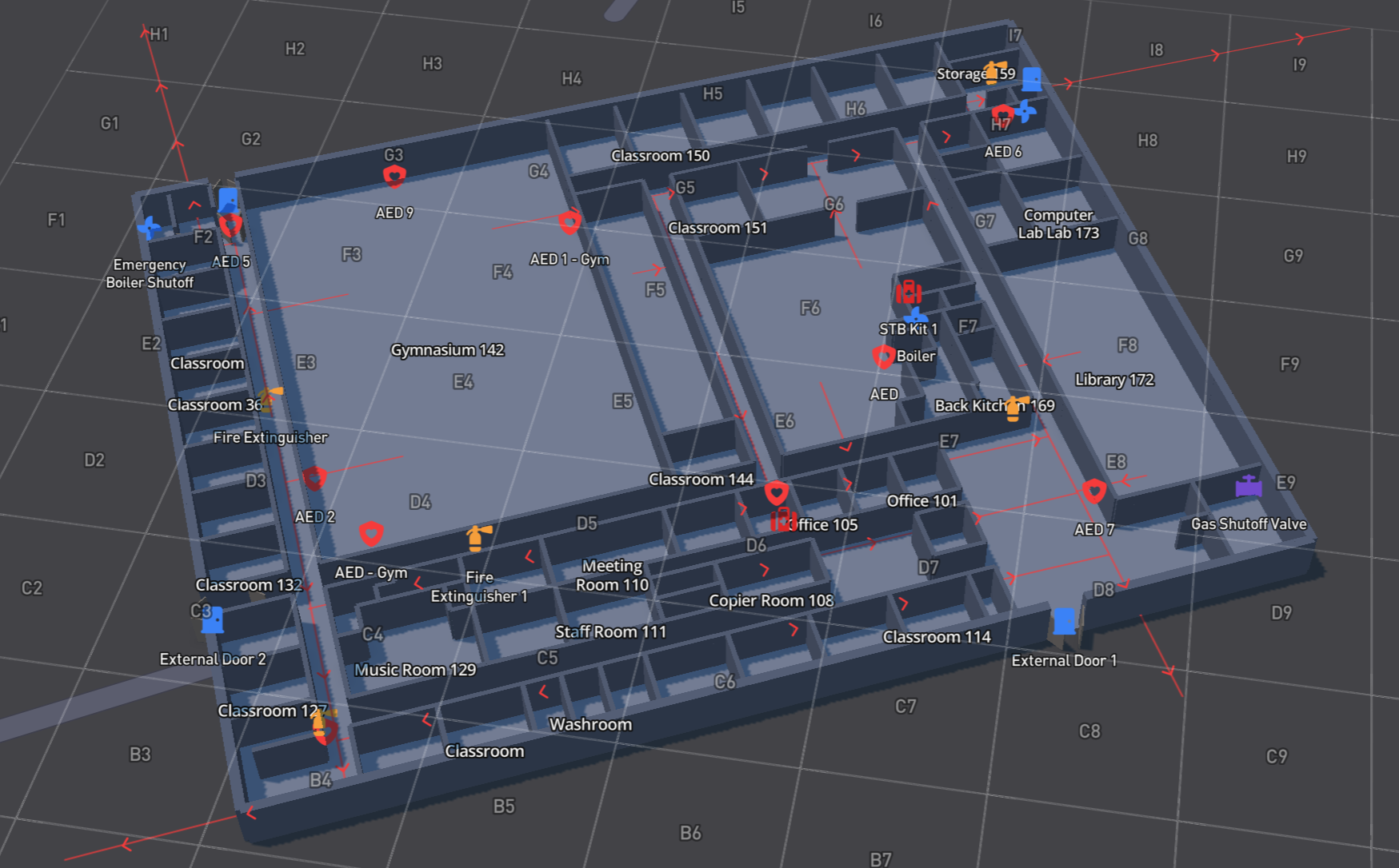
Box Elder School District modernized its facility maps across 25 buildings by digitizing 2 million square feet of space with Gridbase. The effort replaced outdated, inaccurate floor plans with interactive digital maps built for first responders, maintenance staff, and everyday facilities work.
Outdated School Facility Maps and No Maintenance History
Until recently, Box Elder School District’s floor plans and maps were outdated, inaccurate, and hard to read. They were old, poorly rendered files that didn’t reflect renovations, new wings, or changes in asset locations.
“Some of the maps we’re using are pretty outdated and poorly done. Some are even hand-drawn.”
Maps that didn’t reflect the schools’ current state at any given time caused inefficiency across the district.
Locating the right device or asset meant wasting time the district maintenance staff didn’t have. And because door numbers and locations were always changing as schools evolved, the maps couldn’t accurately guide first responders when it mattered most.
The district’s in-house work order system compounded the problem. There was no reliable way to track maintenance history at the room or asset level. Things like records of when a gym floor was refinished, when equipment was last serviced, or what had already been done to fix a recurring issue couldn’t be logged.
Furthermore, Box Elder was paying an outside company for boundary realignment and capacity planning that, with the right tools, they believed they could bring in-house and save the district money.
Interactive School Maps and a Modern Work Order System
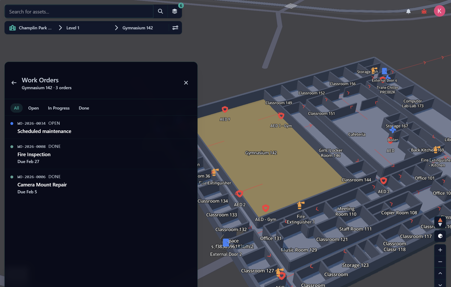
Box Elder found a solution to their challenges in Gridbase:
- Interactive, living digital maps that were easy to update as buildings changed, easy to share with external emergency agencies, and reliable enough to guide decisions during a utility shut-off or evacuation.
- Grid layouts on maps to meet compliance requirements.
- Work order software that could replicate their existing fields and approval workflows, allow technicians in the field to update work orders from a mobile app and attach photos, and preserve historical records by room and asset.
- Secured with SSO through Google.
Beyond the immediate fixes, Gridbase will enable Box Elder to fully own its facilities data in a system flexible enough to support the boundary realignment and capacity planning the district previously outsourced.
What’s Ahead
Box Elder is heading into the Gridbase rollout focused on the areas that caused the most challenges: getting accurate, current maps in place for every school. Gridbase digitized 2 million square feet of space for Box Elder to achieve this. The rollout also includes standing up a work order system that finally contains maintenance history, and giving the Box Elder facilities team a clear, mobile-friendly way to manage assets as buildings change.
Digital Campus Maps and Work Orders
Why do school districts need updated digital campus maps?
Outdated or hand-drawn maps can't keep up with renovations, new wings, or changing room and door numbers, which makes it harder for maintenance staff to locate assets and for first responders to navigate a building during an emergency. Interactive digital campus maps that can be edited and updated as buildings change give facilities teams and emergency responders a map they can rely on that always reflects the current layout.
How are digital campus maps shared with first responders?
Gridbase's digital campus maps can be shared directly with external emergency agencies, giving first responders an accurate, current view of a building's layout. Because the maps can be updated as buildings change (for example, when door numbers change and life-saving equipment is moved), first responders have accurate floor plans to refer to.
What is a school work order system with asset history?
A work order system with asset history logs maintenance at the room and asset level. This includes things like records of when a gym floor was refinished or when equipment was last serviced so facilities teams aren't relying on memory or paper records to track what's already been done. Gridbase's work order software preserves this history and lets technicians update work orders and attach photos from a mobile app in the field.
Can school districts handle boundary realignment and capacity planning in-house?
Yes. With a platform that gives districts full ownership of their facilities data, boundary realignment and capacity planning can be run in-house instead of outsourced. Box Elder School District previously paid an outside company for this work and will be bringing it in-house with Gridbase.
Digital Campus Maps and Work Orders
Why do school districts need updated digital campus maps?
Outdated or hand-drawn maps can't keep up with renovations, new wings, or changing room and door numbers, which makes it harder for maintenance staff to locate assets and for first responders to navigate a building during an emergency. Interactive digital campus maps that can be edited and updated as buildings change give facilities teams and emergency responders a map they can rely on that always reflects the current layout.
How are digital campus maps shared with first responders?
Gridbase's digital campus maps can be shared directly with external emergency agencies, giving first responders an accurate, current view of a building's layout. Because the maps can be updated as buildings change (for example, when door numbers change and life-saving equipment is moved), first responders have accurate floor plans to refer to.
What is a school work order system with asset history?
A work order system with asset history logs maintenance at the room and asset level. This includes things like records of when a gym floor was refinished or when equipment was last serviced so facilities teams aren't relying on memory or paper records to track what's already been done. Gridbase's work order software preserves this history and lets technicians update work orders and attach photos from a mobile app in the field.
Can school districts handle boundary realignment and capacity planning in-house?
Yes. With a platform that gives districts full ownership of their facilities data, boundary realignment and capacity planning can be run in-house instead of outsourced. Box Elder School District previously paid an outside company for this work and will be bringing it in-house with Gridbase.